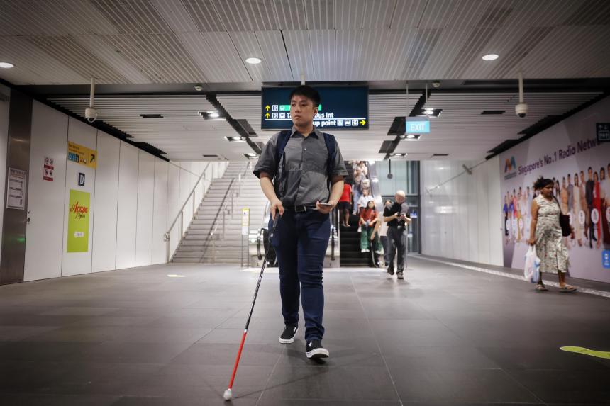

SINGAPORE – Getting from one end of Tampines Bus Interchange to the other may seem like a simple task, but it is a challenge for visually impaired commuters like Mr Joshua Tseng, especially if they happen to be new to the area.
Thankfully, for the past six months, Mr Tseng, 26, has had help from a phone app that literally tells him, turn by turn, how to find his way around the transport hub.
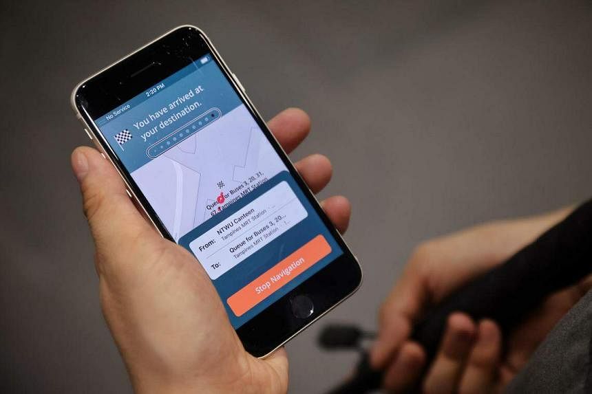
Using audio cues, Waymap-SG will tell him how far away he is from an escalator at nearby Tampines MRT station, for instance, and alert him when he reaches the landing.
Officially launched on Tuesday by SBS Transit (SBST) and British firm Waymap, the app is free to use and available for iOS and Android.
However, its functions are currently limited only to Tampines Bus Interchange and Tampines MRT station on the Downtown Line, which are both operated by SBST.
SBST chief executive Jeffrey Sim said the company chose to launch the app in Tampines as a start, as they wanted to map out a transport hub with retail shops and malls nearby. The plan is to eventually scale up the app so that it covers the rest of SBST’s public transport network and beyond.
Mr Sim said SBST is working closely with the Land Transport Authority on this, and a “good part” of the operator’s bus interchanges and MRT stations will be covered by Waymap-SG by 2024.
At Tuesday’s launch event, Senior Parliamentary Secretary for Transport Baey Yam Keng said in Mandarin: “I hope that soon in the future, this will cover the whole of Singapore, so that those with special needs can move in and out of our public transport system freely without any barriers.”
Mr Sim said SBST and Waymap are also looking to tap the mapping data from the Singapore Land Authority’s OneMap repository. He added: “We hope that this will spark interest (with community partners), and we hope to also work with mall owners.”
SBST said Waymap-SG is the first of its kind in Asia-Pacific. Earlier iterations of the app were previously rolled out in places like New York, London and Brisbane.
Unlike other navigation apps, it does not require GPS, Bluetooth signals or an Internet connection to work. Accurate to up to 1m, it uses a smartphone’s sensors, like the accelerometer and gyroscope, instead.
“Each of these sensors tells us something about the way the phone is moving, so when you take a step, we can tell how long that step is and what direction that step is in,” said Waymap chief operating officer Celso Zuccollo.
“What we do is follow the users as they move through the environment. That means we can do navigation underground where there are no signals.”
For the app to work, facilities such as bus berths, train platforms, escalators and toilets will need to be mapped beforehand, either using existing blueprints or off-the-shelf lidar (light detection and ranging) scanners.
This data is sent to Waymap’s team, who add accessibility information on top of it, like how many landings there are on a particular staircase, or where the buttons of an elevator are located.
Machine learning is also used to continually calibrate the app so that it matches a user’s walking gait and speed. “The app learns about the way you walk, so the more you use it, the better the experience,” Mr Zuccollo added.
SBST’s Mr Sim said the transport operator had contacted Waymap in February about creating a version of its app for Singapore, and it took about nine months to get the project off the ground.
The company also consulted people like Mr Tseng, who came on board as the project’s lead tester.
When asked, Mr Sim was not able to give figures about the cost of the app or how many commuters are expected to benefit, saying only that it is a “worthwhile investment” even if just a handful of people end up using it.

Mr Chia Hong Sen, 27, who is visually impaired and has been testing Waymap-SG for about a week now, said he expects to use it in his daily life.
“We don’t have many such solutions, and the coverage is still pretty limited too,” he added. “What really was lacking, and is still an issue right now, is how to navigate in indoor environments.”
SBST is not the first to launch a navigation tool for the visually impaired. In May 2022, SMRT rolled out its own app, NaviLens, which was trialled in 2021 and works by detecting marker tags embedded in the tactile paving at the operator’s bus interchanges.

Mr Tseng said apps like Waymap-SG give visually impaired people a greater sense of independence and dignity, noting that its functions would also be useful in other public spaces, such as hospitals.
He added: “It will encourage more independent exploration of new places because right now it is something that causes a lot of anxiety... The majority of people with visual impairment fear going out by themselves for this reason.”